Case Study as part of a Web-based
Technical and Regulatory Guidance
Valzinco Mine
Spotsylvania County, Virginia
1. Site Information
1.1 Contacts
Allen Bishop
Department of Mines, Minerals and Energy, Division of Mineral Mining
900 Natural Resource Drive, Ste. 400
Charlottesville, VA 22903
Telephone: 434-951-6317
E-mail: [email protected]
1.2
Name, Location, and Description
The
Valzinco Mine is an abandoned, underground lead/zinc/copper mine operated
in the late 1800s through the mid 1940s. The site is situated at the headwaters
of the Knights Branch watershed in Spotsylvania County, Virginia (38° 10.68'
N, 77° 47.90' W), approximately 1.4 miles south-southwest of Porters,
Virginia on the Belmont 7.5' quadrangle (Figure 1-1). Knight’s Branch flows
into Northeast Creek, which flows into the North Anna River below Lake Anna
Dam. The Anna River empties into the Chesapeake Bay (Seal et al. 2002).
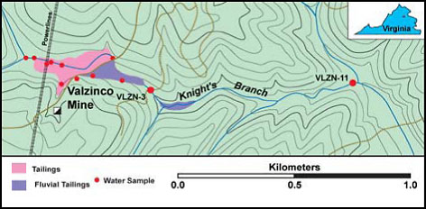
Figure 1-1. Valzinco Mine location map.
The site consisted of underground mine workings and mine tailings deposited within and adjacent to a stream channel. The underground mine workings consisted of multiple levels extending as much as 450 ft deep and 1,500 ft horizontally beneath the valley. Mine processing operations sent mine spoils and waste processing chemicals to a tailings impoundment constructed across the incised channel and floodplain of the valley. Although the mine remained abandoned and unused for mining purposes after the 1940s, it was used as a dumping site for trash (Seal et al. 2002).
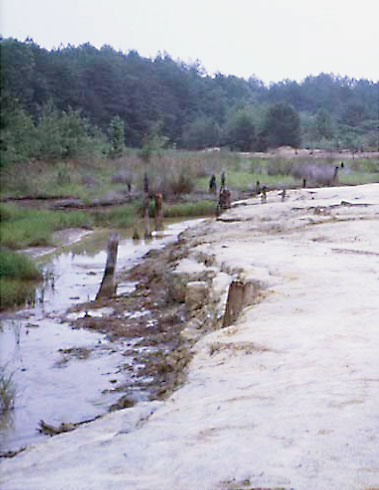
Figure 1-2. Valzinco Mine location map.
Based on a baseline assessment of seasonal variations of acid and metal concentrations in Knight’s Branch, (performed by the U.S. Geological Survey [USGS], U.S. Environmental Protection Agency [USEPA]), the acute and chronic water quality criteria for aquatic ecosystem health were exceeded due to acidity and high dissolved metals concentrations (iron, aluminum, zinc, lead, copper, cobalt, and sulfate). The pH of the water in Knights Branch ranged 2.6–3.9, well below the ambient pH typical for the Virginia Piedmont region, and mean concentrations of a number of metals in the stream were one or two orders of magnitude above USEPA criteria. Approximately 11 acres of on-site land were almost completely barren, vegetation was sparse to nonexistent, and woody vascular plants rarely survived for more than a year on the spoils (Seal et al. 2002, Valzinco Mine Orphaned Land Project: Mine Site Reclamation Reduces Impacts of Acid Mine Drainage Knights Branch, VA).
2.
Remedial Action and Technologies
The following discussion is taken primarily from Valzinco
Mine Orphaned Land Project: Mine Site Reclamation Reduces Impacts of Acid
Mine Drainage Knights Branch, VA.
The Virginia Department of Mines, Minerals, and Energy began reclamation of the site in 2001. The main environmental goals for the reclamation project were to isolate the mine spoils from atmospheric oxygen and reduce or prevent fluvial transportation of spoils downstream in the Knights Branch watershed to depositional environments through the existing channel. Multiple reclamation technologies have been used at this site.
The primary technologies include the following:
- Excavation, treatment, consolidation, and capping treated spoils with 20 tons of lime per acre and bactericide application. This was covered with 2 ft of clean borrow prior to vegetating with native grasses.
- Installation of submerged, sacrificial aggregate high-calcium limestone beds to add alkalinity to system.
- Constructed treatment wetlands: Approximately 4 acres of wetlands was created.
The reclamation activities proceeded in two significant phases through 2007. During Phase 1, 4 acres of spoil was excavated and mixed with bactericide and lime to eliminate acid-producing microbes and neutralize acid. The treated material was buried on site with a 2-ft-thick cap of clean soil and native vegetation to reduce infiltration of precipitation and prevent erosion. In addition, two acres of wetlands containing native vegetation was established in the former tailings pond following the excavation and land-filling of the spoil. Alkalinity was added to the remaining spoil masses through the use of submerged, sacrificial, anoxic limestone drain (ALD) beds, and a new spillway was built to allow for natural stream flow through the site. Below the dam, three step-pool structures were constructed out of dimension stone and riprap to create two additional acres of wetlands.
During the second phase of reclamation, an area of stream channel approximately one acre in size was excavated and the spoil was buried, treated, and covered to support vegetation. Three hundred feet of spoil-laden streambed was also restored by establishing native vegetation on site. Reclamation ended with the planting of more diverse varieties of native plants in the wetland areas and the reseeding of the dam area. Lastly, in December of 2007, approximately 400 wetland and riparian trees and shrubs were planted at the mine and along the restored stream.3. Performance
The following performance discussion is taken primarily from Valzinco
Mine Orphaned Land Project: Mine Site Reclamation Reduces Impacts of Acid
Mine Drainage Knights Branch, VA. Information was also obtained from
Seal et al. 2002.
The final products of this reclamation project included the following:
- revegetation of 11 acres with indigenous plants
- creation of four acres of wetlands
- excavation and consolidation of mine spoils in on-site disposal/landfill cells capped with clean soil
- installation of anoxic limestone drains to add alkalinity to the system
- capping of three mine shafts with reinforced concrete caps and demolition of hazardous structures remaining on the site
- restoration of 300 feet of stream channel
- abatement of AMD and associated heavy-metal contamination, including biocide treatment of selected areas to inhibit AMD development
The full-scale remedies have been in place for over seven years and are considered completed and successful, based on criteria consisting of the establishment and maintenance of vegetation, improved water quality, and reestablishment of a healthy wetland ecosystem. Performance is measured through water quality monitoring. Water quality measurements recorded before and after reclamation (Table 3-1) show an increase in average pH from 3.4 to 5.1, an increase in hardness of 37%, and decreases in total dissolved solids (68%), iron (94%), aluminum (98%), zinc (77%), lead (99.5%), copper (97%), cadmium (94%), and sulfate (81%) relative to mean prereclamation values (Table 3-1). It should be noted that even though significant reductions in dissolved metals have been recorded, the concentrations of copper and zinc remain above USEPA and Virginia hardness-based acute and chronic ecosystem toxicity criteria. The concentration of lead also remains above USEPA hardness-based chronic ecosystem toxicity criteria; however, this elevated concentration appears to be at least partly attributable to the premining lithology and characteristics of the watershed.
Table 3-1. Pre- and post-reclamation
water quality for filtered (0.45 μm) samples at downstream site (VLZN-3)
compared
to USEPA aquatic ecosystem toxicity criteria and Virginia water quality
standards for aquatic life
Parameter |
Units |
Prereclamation |
Post-reclamation
(June 2007) |
USEPA acute toxicity criteria |
USEPA chronic toxicity criteria |
VA acute toxicity
criteria |
VA chronic toxicity
criteria |
||
Low |
High |
Mean |
|||||||
| pH | S.U. |
2.6 |
4.0 |
3.4 |
5.1 |
||||
| Hardness | mg/L CaCO3 |
10.0 |
62.0 |
21.2 |
29.0 |
||||
| Sulfate | mg/L
|
27.0 |
1,400 |
204 |
38.0 |
||||
| Iron | mg/L
|
5.0 |
69.7 |
17.7 |
1.01 |
1.0 |
|||
| Aluminum | mg/L
|
0.6 |
19.5 |
3.1 |
0.051 |
0.75 |
0.087 |
||
| Manganese | µg/L
|
410 |
2,100 |
779 |
1,120 |
||||
| Cadmium | µg/L
|
3.2 |
88 |
15.2 |
0.91 |
1.0 |
0.4 |
1.0 |
0.4 |
| Copper | µg/L
|
49.0 |
2,200 |
311.6 |
9.7 |
5.7 |
4.2 |
5.7 |
3.2 |
| Nickel | µg/L
|
2.0 |
37.0 |
8.5 |
2.3 |
512 |
57 |
512 |
7.3 |
| Lead | µg/L
|
170 |
1,300 |
349 |
1.6 |
17.6 |
0.7 |
17.6 |
2.9 |
| Zinc | µg/L
|
1,900 |
27,000 |
5,750 |
1,320 |
42.2 |
3.2 |
42.2 |
42 |
Positive biological indicators of ecosystem health are also present. Initial wetland vegetation, both planted and naturally occurring, quickly recolonized the site with an average ground cover of >74% after five years. Aquatic vegetation cover averaged >50% after two years, and many plots had coverage >100%. In addition to increases in the overall abundance of reestablished vegetation, the composition, species richness, and abundance of vegetation communities were similar among the restored and nearby reference (unaffected by mine activities) wetlands (>75%, 6.0 spp./m2 vs. 5.5 spp./m2, average cover 74% vs. 67%, respectively).
Accompanying the reestablishment and abundance of native wetland and aquatic vegetation within the site are observations of terrestrial wildlife, including bobwhite quail and wild turkey. In addition, an improvement in the aquatic ecosystems and return of herpetofauna to the wetland and aquatic communities at Valzinco are supported by the fact that two amphibians (southern leopard frog, pickerel frog) and two aquatic reptiles (brown water snake and northern water snake) were captured on the site during the fifth year.4.
Costs
The total cost of the project was $500,000 (consisting of capital cost of
$400,000 and operation and maintenance cost of $100,000). This cost was funded
using $95,000 in grants from the USEPA’s 319 Non Point-Source Implementation
Grant Program, administered by the Virginia Department of Conservation and
Recreation (VA DCR), and $75,000 from Virginia’s Water Quality Improvement
Fund, also administered by VA DCR. The remainder of the balance came from
the Virginia Department of Mines, Minerals and Energy, Division of Mineral
Mining Orphaned Land Program (Valzinco Mine Orphaned Land Project: Mine
Site Reclamation Reduces Impacts of Acid Mine Drainage Knights Branch, VA).
5. Regulatory Challenges
The success of the Valzinco Mine Reclamation Project was built upon technical
expertise, monitoring, and assistance stemming from a collaborative group
of participants from the Virginia Institute of Marine Science, the USGS,
VA DCR, the Virginia Department of Environmental Quality, the Virginia Department
of Game and Inland Fisheries, the U.S. Army Corps of Engineers, the Virginia
Department of Mines, Minerals and Energy, the mineral mining industry, private
contracting companies, and the public.
One major technical regulatory challenge was obtaining the Clean Water Act permit to disturb the impaired stream channel. This required getting agreement from the other regulatory agencies that administer the Clean Water Act.
6. Stakeholder Challenges
There were no significant public or stakeholder issues associated with the
project.
7. Other Challenges and Lessons
Learned
There were no challenges or lessons learned due to the reclamation work at
the mine site proceeding as expected.
8. References
Seal, R. R. II, A. N. Johnson, J. R. Hammarstrom, and A. L. Meier. 2002. Geochemical
Characterization of Drainage Prior to Reclamation at the Abandoned Valzinco
Mine, Spotsylvania County, Virginia. U.S. Geological Survey Open File
Report 02-360.
Valzinco Mine Orphaned Land Project: Mine Site Reclamation Reduces Impacts of Acid Mine Drainage Knights Branch, VA. n.d. https://www.epa.gov/reg3wapd/pdf/pdf_nps/success/va/ValzincoMineOrphanedLandProject_FINAL.pdf.