Case Study as part of a Web-based
Technical and Regulatory Guidance
Boston Mill Site
Pilot Study
Cochise County, Arizona
1. Site Information
1.1 Contacts
Raina M. Maier, Ph.D.
The University of Arizona
Department of Soil, Water and Environmental Science
429 Shantz Building #38
Tucson, AZ 85721
Telephone: 520-621-7231
E-mail: [email protected]
Heather F. Henry, Ph.D.
Program Administrator
Superfund Research Program
National Institute of Environmental Health Sciences
Telephone: 919-541-5330
E-mail: [email protected]
1.2 Name, Location, and Description
The Boston Mill mine tailings site is located in Cochise County, Arizona.
It is adjacent to the San Pedro River in the San Pedro River National Conservation
Area (SPRNCA), approximately 3.2 km (2 miles) south of Fairbank, AZ, and
12.6 km (8 miles) southwest of Tombstone, AZ, at an elevation of 1192 m (31°40′38.6″N,
10°10′53.4″W). It is one of five mill sites along the upper San Pedro River,
within the SPRNCA, that were active from 1879 to 1887 for processing silver
and gold ore that was brought from mines in Tombstone, AZ. The site originally
covered approximately 2.8 ha (7 acres) and was be divided into three areas:
an upper tier near the mill foundation, a lower tier at a slightly lower
elevation south of the upper tier, and tailings across the railroad tracks
in the floodplain (Figure 1-1).
Preliminary data provided by the Bureau of Land Management (BLM), which owns and manages the site indicated that the upper tier has the highest concentrations of heavy metals. This area had shallow layer of tailings (10–20 cm) and included completely barren areas to the west of the mill foundation and some areas with patchy vegetation on the eastern side composed primarily of big sacaton grass (Sporobolus wrighti Munro ex Scribn) and mesquite (Prosopis spp.). This partial vegetation suggests that natural attenuation has slowly occurred on the tailings during the past century. For this reason the Boston mill site is considered to be a moderately impacted mine tailings site. Nevertheless, barren areas still pose a source of concern for windborne dispersion and water erosion of tailings into the San Pedro River and the surrounding region, which is a wildlife refuge and hiking area.
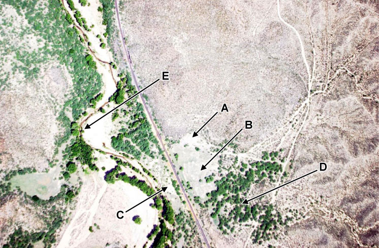
Figure 1-1. Aerial view of the Boston Mill mine tailings site.
(A) upper tier, (B) lower tier, (C) tailings across railroad tracks in the floodplain of the San Pedro River,
(D) off-site control, (E) the San Pedro River.
Selected physical and chemical characteristics were determined for samples from the upper tier site (Tables 1-1 and 1-2). The alkaline pH and the presence of organic carbon are key parameters that indicate this as a moderately stressed site. In severely stressed sites, the pH is usually acidic (<3–4), and there is essentially no organic matter. In this site the pH is moderately alkaline, ranging from 8.3 to as high as 9.8 in one sample, and total organic carbon values ranged from 8.6 to 21.4 mg/kg with an average of 11.6 mg/kg. These values compared very favorably to off-site control samples (area D in Figure 1-1), which had a pH of 8.7 and a total organic carbon content of 4.8 mg/kg. The big difference between the tailings and the off-site control samples was the total metal concentrations, which were greater in the mine tailings samples for all metals measured except aluminum (Table 1-2). In particular, lead, mercury, and cadmium were elevated up to 100-fold over the off-site control samples.
Table 1-1. Boston Mill upper tier
mine tailings characteristics
(Each value is the average and standard deviation of 12 samples taken from the
site.)
Parameter |
Value |
| pH | 8.8 ± 0.4 |
| Cation exchange capacity, cmol/kg | 26.8 ± 3.2 |
| Sand, % | 48.6 ± 12.4 |
| Silt, % | 36.5 ± 7.7 |
| Clay, % | 15.0 ± 5.2 |
| Total organic carbon, g/kg | 11.6 ± 3.9 |
| Total nitrogen, g/kg | 0.43 ± 0.21 |
Table 1-2 .Total metal concentrations (mg/kg) for
the Boston Mill upper tier mine tailings.
(Each value is the average
and standard deviation of 12 samples from the Upper Tier area and
the average
and deviation from the mean of duplicate samples taken in the off-site
control area.)
Metal |
Upper Tier |
Off-site Control |
| Lead | 13,700 ± 3810 |
127 ± 3 |
| Arsenic | 630 ± 230 |
7 ± 1 |
| Mercury | 410 ± 210 |
3 ± 0 |
| Zinc | 6,700 ± 2100 |
989 ± 139 |
| Copper | 2,800 ± 970 |
97 ± 8 |
| Iron | 17,000 ± 4,200 |
10,500 ± 1,450 |
| Manganese | 54,100 ± 20,100 |
730 ± 69 |
| Cadmium | 105 ± 39 |
1 ± 0 |
| Aluminum | 10,800 ± 3,700 |
14,300 ± 3,500 |
2. Remedial Action and Technologies
Phytostabilization
is a phytoremediation technology that involves the establishment of a plant
cover that acts to reduce all spreading mechanisms for contaminants within
the mine tailings (Mendez and Maier 2008). These include windborne dispersion,
water erosion, and leaching. At the same time, a plant cover acts to stabilize
soil contaminants by altering the water flux through the soil by incorporating
free contaminants into the roots and rhizosphere and by improving ecosystem
structure and function within the tailings. The challenge with phytostabilization
in arid and semiarid environments is that plant establishment is often
limited by high levels of metals and extreme pH in addition to the other
challenges that arid environments pose to plants (e.g., low water availability,
low organic matter, salinity, and high temperatures). In general, the development
of a persistent vegetative cover depends on selecting plant species suitable
to site conditions and amending tailings with organic matter that improves
soil properties that favor plant growth.
This case study describes a phytostabilization effort on a barren section of the Boston Mill site referred to as the “upper tier,” a section approximately 1.5 acres with high concentrations of heavy metals (Table 1-2). The aim of the phytostabilization effort was to jump-start native plant establishment. A pilot study determined whether or not water and composting was essential for plant establishment; then the final closure process was initiated. This case study describes the methods to initiate native plant growth and to monitor the success of plant establishment. The ultimate goal of this effort was to reduce dispersal of tailings by achieving a self-sustaining plant cover.
2.1 Pilot Study at the Boston Mill SiteAn initial pilot-scale phytostabilization study was performed by the University of Arizona in the upper tier area of the Boston Mill site (Rosario et al. 2007). This study compared the survival and growth of greenhouse transplants of a native saltbush species, Atriplex canescens, in the site with and without added compost amendment. The plant chosen for this study was four-wing saltbush, which is a perennial halophytic subshrub native to Arizona, California, Nevada, and Utah (USDA NRCS 2005). This plant is considered drought tolerant and has been observed encroaching into other historical mine tailings sites as well as the Boston Mill site. Four-wing saltbush transplants were germinated and grown in the greenhouse for 2 months in a 2:1 sand/compost mix in 0.375 L pots. The compost was commercial composted mulch (Sunshine mix no. 1, Sun Gro Horticulture). This material was also used as the compost amendment in the field trial.
Major results of this pilot study showed the following:
- 80% of all transplants survived with minimal inputs of water (a total of 44 L/plant over 18 months) and no fertilizer or organic carbon amendments.
- Biomass increased significantly over the first 11 months of the study showing a 30-fold increase in plant volume. However, plants did not grow further from 11 to 18 months (the end of the study). This may have been due to water stress or metal toxicity. Plants were not monitored beyond 18 months.
- There was no difference in plant biomass produced between compost and no compost treatments.
- Neutrophilic heterotrophic bacteria increased 10- to 100-fold in planted plots and can serve as an indicator of revegetation success.
- Of the metals present in the tailings, only lead (Pb) was translocated into shoot material in levels that exceeded the guidelines (up to 3-fold) for metal toxicity limits for domestic animals, specifically cattle (Table 2-1). A recent National Research Council report (NRC 2005) states the limit for Pb is 100 mg/kg.
- Plant shoot metal content at the end of the trial was elevated up to 80-fold over levels found in saltbush naturally established in nearby areas (Table 2-1). Metal uptake was not attributed to total soil metal concentrations because there was no correlation between soil metal concentration and plant metal uptake (Pearson’s correlation coefficient r = −0.22 to 0.45). However, there was a positive correlation between Fe uptake and uptake of other metals, including Pb, copper (Cu), arsenic (As), manganese (Mn), aluminum (Al), and mercury (Hg) (r = 0.89 to 0.98).
Table 2-1. Total metal contenta (mg/kg) in four-wing saltbush and transplant shoots 18 months following planting
Metal(loid) |
Tailings transplant shoots |
Off-site control plant shootsb |
| Fe | 270 ± 80 |
102 ± 8.0 |
| Cu | 33 ± 11 |
5.7 ± 2.5 |
| Zn | 195 ± 47 |
67 ± 35 |
| As | 5.7 ± 3.6 |
0.1 ± 0.1 |
| Cd | 6.5 ± 2.0 |
0.6 ± 0.5 |
| Hg | 1.0 ± 0.6 |
0.04 ± 0.02 |
| Pb | 314 ± 150 |
4.1 ± 5.6 |
| Al | 230 ± 94 |
58 ± 30 |
| Mn | 880 ± 310 |
200 ± 46 |
| a Total metal content is reported as the average and standard deviation of eight different plant samples from the tailings site and four different plant samples from the off-site control area. |
| b Shoot materials were collected from indigenous four-wing saltbush in an area adjacent to the tailings pile to represent background metal concentrations. |
2.2
Final Closure at the Boston Mill Site
Given
the promising results of the pilot study, the Bureau of Land Management (BLM)
decided to work with the University of Arizona to bring the site to closure.
To consolidate the tailings into one phytostabilization treatment area, the
BLM first removed the tailings from both the lower tier area and from the
site across the railroad tracks in the floodplain and placed them onto the
upper tier tailings area, which is approximately 1.5 acres (Figure 1-1).
In addition, the BLM placed 6 inches of locally collected topsoil onto the
consolidated tailings. The University of Arizona then seeded the consolidated
tailings and evaluated germination, plant cover, and the impact of weather
and rain events on the success of revegetation. This study and the evaluation
criteria used are described in detail below:
On July 25, 2006 the upper tailing impoundment of the Boston Mill site was seeded with four drought- and salt-tolerant plant species (Table 2-2). Seeds for these and other native plants are available from several sources, including the following:
- Western Native Seed (http://www.westernnativeseed.com)
- Plants of the Southwest (http://www.plantsofthesouthwest.com)
- The Cactus Store (Phoenix Desert Nursery) (http://www.cactusstore.com)
The impoundment was shallow tilled 3–4 inches deep using a rotary cultivator. Seeding was performed using hand-operated whirling broadcasters, and then the seeds were lightly mixed into the soil surface with a chain-link drag harrow. Site conditions and germination progress were observed every two to three weeks following planting for the first months months and bimonthly thereafter.
Table 2-2. Selected plant species and seeding rates
| Species | Seeding Rate |
||||
July 2006 |
July 2007 |
||||
| Common name | Latin name | kg/ha |
lb/acre |
kg/ha |
lb/acre |
| Alkalai sacaton | Sporobolus airiodes | 3.1 |
3.5 |
14.5 |
16 |
| Four-wing saltbush | Atriplex canescens | 5.8 |
6.5 |
18.2 |
20 |
| Quailbush | Atriplex lentiformis | 12.9 |
14.5 |
18.2 |
20 |
| Inland saltgrass | Distichlis spicata | 4.7 |
5.31 |
9.1 |
10 |
A site survey was conducted in October 2006 to evaluate plant growth and
species composition. A 110 × 150 foot (33.5 × 45.7 m) sampling grid was established
within the boundaries of the impoundment. Ten grid point locations and five
nongrid point locations were randomly selected for soil and plant sampling.
At each sampling location a 1 m2 PVC frame was laid on the soil surface.
Within the square frame the overall plant canopy coverage and species composition
was visually estimated. A total plant number count of four-wing saltbush,
quailbush, and mesquite was also made. A digital photo of each location was
taken at about 5 feet (.1.5 m) centered above the PVC frame. Soil samples
were taken to a depth of 3 feet at each of the grid point locations for use
later to evaluate plant metal uptake.
In May 2007 the site survey was repeated using the same sampling locations. Three sampling points had to be relocated due rodent activities which had disturbed the sampling points. All remaining pigweed debris left from the previous year was removed, and only the remaining intact vegetation was evaluated.
There was limited revegetation success on the northern half of the impoundment resulting from surface erosion (due to heavy rains in summer 2006) and lack of water storage for plant growth. Therefore, the northern half of the impoundment was reseeded using heavier seeding rates and more aggressive site preparation techniques on July 21, 2007 (Table 2-2). The area to be reseeded was shallow-ripped to 6 inches deep using the ripper shanks on a Gannon box grader. The soil surface was mixed and large soil clods broken up using a spike-toothed harrow. The selected species were seeded at the selected rates by either hand-broadcasting the larger seed or using a hand-operated whirling broadcaster for finer seed. The seed was mixed into the soil surface using spike-toothed and chain-link drag harrows, followed by reripping the planted surface in a circular concentric pattern around the impoundment. This process resulted in a rough surface rilled every 12 inches. The objective was to provide an improved soil surface condition to increase rain infiltration and initially reduce runoff. A front-end loader was then used to scrape up a berm between the north and south half of the impoundment as well as along the northern edge of the impoundment in low areas where runoff had previously occurred. Originally, establishing larger and a more frequent series of berms across the reseeded area was proposed, but equipment issues and concerns with regard to exposing capped tailings led to establishing the smaller perimeter berms instead (see Section 7: Topography).
On October 2007 the site survey was again repeated. For this survey the original sampling grid was split in two (northern half and southern half) to look at the effect of the July 2007 reseeding (northern half only). Original sampling locations were reused, and additional random locations were selected such that there was a total of 11 sampling locations per sampling grid.3. Performance
The active monsoons in summer 2006 resulted in germination of seed within
about two weeks of planting; however, the predominant species (pigweed) growing
on the site was not part of the seed mix selected. Pigweed is common to the
area, and seeds were obviously present in the soil cap material used for
the site. Other volunteer plants species were also present, including mesquite,
morning glory, and a variety of unidentified grasses and forbs. Two of the
four seeded species were observed to have germinated: four-wing saltbush
(Atriplex canescens) and inland salt grass (Distichlis spicata),
with the best germination by inland salt grass. Sheet erosion and surface
rilling of the impoundment (mostly on the northern half) was noted, as well
as crusting of the surface on the northern half of the site. Most plant growth
and all of the pigweed growth was limited to the southern half of the impoundment.
It appeared that summer rainfall had been received in short, intense durations.
Because of the slightly concave shape of the impoundment’s north/south slope,
greater erosion, more rainfall runoff and seed washout, and less rainfall
infiltration (water storage) were expected on the upper slope (northern half),
while the lower portions of the slope, in general, could expect the exact
opposite, thereby creating more conducive conditions for seedling growth
on the southern half of the site.
Three months after planting (October 2006), the pigweed was drying and nearing the end of its growth cycle. Significantly more of the planted species had germinated. Four-wing saltbush, quailbush, and inland salt grass were all noted present. Inland salt grass was the most prevalent of the seeded species. All species appeared most successful on the southern half of the impoundment, though seedlings could now be observed on the northern half of the impoundment along rill lines and in low spots on the surface. No Alkalai sacaton was observed growing on the impoundment at this time; the planting date may have been too late to see successful germination. Numerous unidentified volunteer species in addition to pigweed were also observed.
In October 2006 the average total canopy cover for the site was 16% (±22), 1% (±2) on the northern half, and 28% (±23) on the southern half. Pigweed represented 42% (±41) of the overall species composition, 19% (±33) of the northern half composition, 68% (±33) of the southern half composition (Table 3-1). In May 2007, with the effect of pigweed removed, the average total canopy cover for the site was 10% (±10), 3% (±7) on the northern half, and 16% (±9) on the southern half (Table 3-1). Inland salt grass was the predominant species of the overall canopy composition. As can be seen by the reported standard deviations, observations were wide-ranging and highly variable. This effect, however, is not unexpected particularly when considering the severity of the growing conditions and the lack of irrigation. Species composition estimates may be misleading as to the success of the seeded species when compared to the volunteer pigweed. Pigweed is a rapid-growing, invasive annual, and the selected seeded varieties are slower-growing, adaptive perennials. Over time, assuming the perennials survive establishment, the canopy cover estimates, as well as the percent composition, are expected to greatly increase as these species mature.
During a site visit in April 2007 it was observed that winter rains had initiated new growth of inland salt grass, but during the May visit it appeared that lack of rainfall in April and May returned this plant to senescence. In addition, considerable grazing pressure on surviving species was observed during site visits, particularly the two Atriplex varieties. In several areas where well-established plants had been noted, plants began to slowly disappear over the winter months as either deer and/or rodents browsed on the foliage. Note that metal uptake into plant shoot tissue was not measured in this study. In the pilot study using Atriplex canescens, it was noted that only Pb exceeded the guidelines for metal toxicity limits for domestic animals, specifically cattle. Work with other Atriplex species, specifically Atriplex lentiformis,suggests that not all Atriplex species accumulate Pb. Therefore, this closure study compared the two Atriplex species for their survival.
As proposed in June 2007, the northern half of the impoundment was reseeded, and the soil surfaced was rilled with the contours of the slope. Initially, August rains were less than the previous summer, and there was limited germination (even of the volunteer pigweed). By September additional rainfall had been received, and germination of the reseeded species was evident as well as the return of species planted the previous year on the southern half. Most species present at this time were still less than 5 cm (2 inches) high. Pigweed was visually the predominant species, but unlike the previous year it represented less the 50% of the vegetation present. As evidence that the surface preparation during the northern half reseeding was effective, it was noted that signs of surface erosion were less than typically observed and that significant moisture was present in the furrows between rills. Some areas had some standing water, and there were signs of some crusting where standing water had evaporated or infiltrated the soil.Table 3-1. Canopy cover measured October 2006 through August 2008
% Canopy cover |
||||
Total |
Northern Half* |
Southern Half** |
||
| Overall | October '06 | 16 ± 22 |
1 ± 2 |
28 ± 23 |
| May '07 | 10 ± 10 |
3 ± 7 |
16 ± 9 |
|
| October '07 | 13 ± 14 |
9 ± 8 |
18 ± 12 |
|
| August '08 | 26 ± 33 |
6 ± 5 |
46 ± 36 |
|
| Species Composition | % Composition of total canopy cover |
|||
Alkali sacaton |
October '06 | 0 |
0 |
0 |
| May '07 | 0 |
0 |
0 |
|
| October '07 | 15 ± 27 |
4 ± 8 |
26 ± 35 |
|
| August '08 | 14 ± 18 |
12 ± 16 |
16 ± 21 |
|
Four-wing saltbush |
October '06 | 13 ± 29 |
21 ± 39 |
4 ± 11 |
| May '07 | 4 ± 14 |
0 |
7 ± 19 |
|
| October '07 | 15 ± 23 |
29 ± 26 |
0 |
|
| August '08 | <1 ± 3 |
0 |
1 ± 4 |
|
Quailbush |
October '06 | 0 |
0 |
0 |
| May '07 | 0 |
0 |
0 |
|
| October '07 | 8 ± 23 |
1 ± 3 |
14 ± 32 |
|
| August '08 | 0 |
0 |
0 |
|
Inland salt grass |
October '06 | 21 ± 33 |
17 ± 37 |
24 ± 28 |
| May '07 | 58 ± 50 |
29 ± 49 |
78 ± 39 |
|
| October '07 | 22 ± 33 |
16 ± 26 |
28 ± 39 |
|
| August '08 | 3 ± 11 |
0 |
6 ± 15 |
|
Pigweed |
October '06 | 42 ± 41 |
19 ± 33 |
68 ± 33 |
| May '07 | 0 |
0 |
0 |
|
| October '07 | 24 ± 28 |
29 ± 29 |
19* ± 28 |
|
| August '08 | 54 ± 40 |
55 ± 40 |
53 ± 40 |
|
other |
October '06 | 1 ± 3 |
1 ± 2 |
3 ± 4 |
| May '07 | 0 |
0 |
0 |
|
| October '07 | 8 ± 14 |
3 ± 6 |
12 ± 18 |
|
| August '08 | 10 ± 14 |
5 ± 11 |
15 ± 16 |
|
| * Nothern half of impoundment first planted July 25, 2006
and replanted July 21, 2007 **Southern half of impoundment planted July 21, 2006 |
||||
The October 2007 plant survey revealed (Table 3-1) continued vegetation
development on the southern half plant in 2006 and improved germination conditions
for the northern half reseeded in 2007. The average total canopy cover for
the site was 13% (±14), 9% (±8) on the northern half, and 18% (±12) on the
southern half. While these numbers appear little changed from the observations
made a year earlier, it should be noted that the plants observed in October
2007 were more numerous than in 2006 but smaller, with less canopy due to
slower germination and lower rainfall. In addition, the pigweed population
was also smaller in October 2007 and therefore also had smaller canopy values.
Pigweed in October 2007 represented only 24% (±28) of the overall species
composition, compared to 42% (±41) in October 2006 (Table 3-1). Alkalai
sacaton and quailbush, which had little to no measurable presence during
previous surveys, was now present on both sides of the impoundment. It may
be that these species do better after overwintering in the environment and
that most of the plants observed were actually from the first planting.
In January 2008, as expected, native vegetation in the surrounding area as well as vegetation established on the impoundment was well into winter senescence. There was evidence of grazing of the grasses and Atriplex species on the impoundment, apparently from both deer and rodents. Winter rains from November and December had eroded the berms created the previous July, and now surface flow and erosion were evident. Very little plant growth occurred until the after the start of the monsoon season in early July. While monsoon storms provided the much-needed moisture for plant growth, it also promoted further erosion of the established surface topography and berms. There is little soil structure or organic matter in the soil cap to hold together the berms and rills created the previous July. In addition, plant growth this season was so slow that little benefit was gained from soil-stabilizing roots. Surface runoff from the impoundment also resulted in the further development of gulley erosion from the impoundment.
The plant survey at the end of August 2008 (Table 3-1) showed continued vegetative development on the southern half of the impoundment, an increase in the numbers of nonseeded plant species and further establishment of Alkalai sacaton. The average total canopy cover for the site was 26% (±33), 6% (±5) on the northern half, and 46% (±36) on the southern half. We observed a major increase in canopy cover and species present on the southern half of the impoundment. While pigweed was still the predominant species, this year’s wet monsoon season also brought out many wildflower species not previously observed, brittle bush being predominant among these. The canopy coverage for the northern half slightly decreased. At this point in time (about midway through the August/September growing season), we saw little improvement of the plant growth on the northern half on the impoundment and an overall decrease in the occurrence of quailbush and inland salt grass. Four-wing saltbush was still present with numerous well established plants 12–18 inches in height mostly on the southern half of the impoundment. The study area will continue to be monitored through 2009.
Conclusions
We have shown that with surface preparation and species selection, vegetation
can be established (both seeded and native unseeded species) on the impoundment
without supplemental irrigation. Soil surface erosion and increasing soil water
storage from natural rainfall remain major concerns and represent the biggest
restrictions to the long-term success of such reclamation efforts. The growing
season here is monsoon dependent but seems to occur from late July to mid-late
September (following the start and end of the monsoon season). The third year
(2008) was wetter (both winter and summer rains) than previous seasons and
thus brought out more native unseeded species, and a marked increase in the
canopy cover of the southern half of the impoundment was observed.
The success on the southern half of the impoundment in part is because the topography helps to retain surface runoff and increase the soil water storage. To establish vegetation with similar success on the northern half of the impoundment will require further physical measures to control erosion and retain moisture. A small fenced in area on the northern side of the impoundment is evidence of this. This fenced-in area was used for a sub-study and showed similar results to the northern half of the impoundment in 2006. In 2007 it was re-seeded along with the northern half, except each subplot area was contoured into shallow basins. The result was a decrease in surface runoff, an increase in water retention (we observed standing water in Sept 2007 and July 2008), and a marked improvement in over-all plant germination and growth (Aug 2008). It is believed that with more physical preparation of the surface that surface runoff could be further reduced, and increase the revegetation success. In addition to or as a part of the physical preparation, the incorporation of natural debris and organic matter into the surface of the impoundment could significantly aid in reducing and retaining surface runoff as well as increasing soil water storage for plant and plant root development. This in turn should help to further establish the succession of a vegetative community on the impoundment.
4. Cost
None reported.
5. Regulatory Challenges
None reported.
6. Stakeholder Challenges
None reported.
7. Other Challenges and Lessons
Learned
Concerns
We
have thus far shown that with surface preparation and species selection
we can indeed establish vegetation (both seeded and native unseeded species)
at this site without supplemental irrigation. The success of the vegetative
effort, however, is directly related to the quantity and distribution of
the annual rainfall received and retained on the impoundment itself. Storm-water
runoff and soil surface erosion represent the biggest limitations to the
long-term success of this phytostabilization effort.
We have noted that the areas of greatest success are those areas where surface runoff is slowed and captured for soil water storage. These areas show the intended result of decreased soil surface and side-slope erosion. Soil erosion and lack of rainfall retention over most of the impoundment, however, is impeding the establishment of plants which would in turn reduce erosion via root stabilization and runoff control. The northern half of the impoundment and the eastern and western slopes are showing signs of increased surface rill erosion and gulley formation.
We believe to have a better long-term outlook for the stability of the impoundment, measures to at least temporarily reduce the surface runoff and erosion should be implemented to allow the vegetation a chance to become established. Reducing surface runoff and increasing rainfall retention may in part be accomplished by altering the topography of the site and incorporating a temporary organic matter source.
Topography
Creating topography on the surface of the impoundment such as deep concentric
berms or divoting the impoundment with small, shallow, level basins would
provide a trap for rainfall to collect and reduced surface runoff. Following
the second seeding in July 2007, we completed the soil surface preparation
by mechanically rilling the surface in concentric rings around the impoundment.
Initially, this tactic proved effective at retaining rainfall, reducing runoff,
and aiding in the initial germination of seed. However, over several months
these shallow rills had eroded and provided little benefit a year later.
In place of small rills, berms (6–8 inches high, 24–36 inches apart) could
be created as concentric topographic rings. These would capture rainfall
for plant growth and create a longer-lasting and more effective physical
barrier to reduce the overall runoff from the site. These berms would partially
erode over time but would provide increased opportunity for plant establishment.
In place of topographic berms the surface could be prepared by divoting the impoundment with small, shallow, level basins (0.3 × 6 feet, 0.4–6 inches deep). During the second seeding in July 2007, we established an area of small subplots on the northern half of the impoundment. These small basins, hollowed out with hand tools and bermed with the soil removed from the basin, were also effective at aiding initial seed germination. Unlike the surface rilling used elsewhere, these basins survived erosive activities, retained rainfall, and were still intact more than one year later. More importantly, these catchments resulted in thriving vegetative growth one year after seeding.
Although initial trials showed soil amendments were not essential for plant survival, in retrospect, amendments may have served to minimize the runoff issues encountered. The addition of organic matter via organic mulches, green waste, chipper waste, etc. would also be of benefit in slowing surface runoff, temporarily increasing water retention, reducing evaporative losses, providing a bed for germination, and protecting seeds from runoff translocation.
Use of surrounding natural materials (logs, flood debris, grass cuttings, etc.) would also be of use not only as a source of organic matter but also to construct barriers to surface flow by either damming up surface flow or spreading out the concentrated runoff across the impoundment. This would be of particular benefit in those areas where significant erosion is currently taking place.
There are a number of commercial options also available for use as physical barriers to surface runoff, such as fiber mattes, jute blankets, hay rolls, etc. These products are typically staked in place following seeding along the contour of the slope. They act to slow surface runoff as well as trap and hold sediments, organic mater, and seed.
Further vegetative success would be seen by decreasing the slope of the impoundment side slopes by extending out the foot of the slopes. Side slopes should then be back-sloped and terraced to decrease surface runoff and increase water retention and then seeded. The application of commercial runoff barriers would probably be the easiest to install along the side-slope perimeter, but this could be accomplished with naturally occurring materials in the area as well.
In general, the future success of the site stabilization using vegetation without supplemental irrigation will require the implementation of measures to control and soil erosion and reduce surface runoff to allow vegetation a chance to become established. Once established the vegetation will in turn reduce erosion via root stabilization and runoff control, as well as provide the other benefits of phytostabilization with regard to the mine tailings below.8. References
Mendez, M. O., and R. M. Maier. 2008. “Phytostabilization
of Mine Tailings in Arid and Semiarid Environments: An Emerging Remediation
Technology,” Environmental
Health Perspectives 116: 278–83.
NRC (National Research Council). 2005. Mineral Tolerance of Animals, 2nd rev. ed. Washington, D.C.: National Academies Press.
Rosario, K., S. L. Iverson, D. A. Henderson, S. Chartrand, C. McKeon, E. P. Glenn, and R. M. Maier. 2007. “Bacterial Community Changes During Plant Establishment at the San Pedro River Mine Tailings Site,” Journal of Environmental Quality 36: 1249–59.
USDA NRCS (U.S. Department of Agriculture Natural Resources Conservation Service). 2005. “The PLANTS Database,” Vers. 3.5. http://plants.usda.gov/java/. Verified May 3, 2007. Data compiled from various sources by M. W. Skinner. National Plant Data Center, Baton Rouge, La.