Case Study as part of a Web-based
Technical and Regulatory Guidance
Kerramerican Mine Site
Hancock County, Maine
1. Site Information
1.1 Contacts
Rob
Peale
Maine Department of Environmental Protection
Telephone: 207-287-7679
E-mail: [email protected]
Fred Lavallee
Maine Department of Environmental Protection
Telephone: 207-287-7677
E-mail: [email protected]
Tracy Weston
Project Manager
Maine Department of Environmental Protection
Telephone: 207-287-4862
E-mail: [email protected]
1.2 Name, Location, and Description
The Kerramerican Mine property is located along Route 15/176 in Blue Hill,
Hancock County, Maine (Figure 1-1). The property is owned separately by DLM
Associates and two private owners. The zinc and copper mine, which operated
1971–1977, was officially closed under an agreement with the Maine Department
of Environmental Protection in 1981. An on-site access road forms the border
between a mill process area and a waste disposal area on the property. The
53-acre waste disposal area consists of two former tailings ponds that have
been covered with till and vegetation. The mill process area was formerly
occupied by a hoist house, former service and concentrator buildings, foundations
of former thickener units, and the headframe of a mine shaft. Three unnamed
intermittent streams and Carleton Stream flow through the property. The property
is bordered by Second Pond to the west, Carlton Stream to the south, and
sparsely developed residential properties to the east and north.
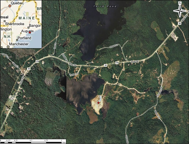
Figure 1-1. Kerramerican Mine Site. Created with ESRI ArcView software using Microsoft Bing maps.
In 1880, mining operations began in the area surrounding the property known as the Blue Hills Copper Mining District. Mine tailing wastes, such as copper slag from mining operations in the area, were disposed of along the shore of Second Pond. In 1964 and 1965, Black Hawk Mining Ltd. (Black Hawk) and Dennison Mines Ltd. of Toronto conducted extensive underground development of the ore body located directly beneath Second Pond. In 1971, Kerramerican Inc. (Kerramerican) constructed a mining facility on the property to produce zinc and copper from ore extracted from the mine located beneath Second Pond. The on-site streams were dammed to construct two tailings ponds. Reportedly, waste slag material from Second Pond was used in the construction of the Kerramerican facility and a dike separating the two tailings ponds. Between 1971 and 1977, operations at the property included the following: concentrating of raw material by crushing and grinding ore, adding water to produce a fine slurry, and extracting mineral concentrates using an alkaline floatation process. Historically, reagents used in the milling process included unknown quantities of sodium sulfate, copper sulfate, lime, and other unknown reagents. Wastewater and tailings were discharged to the tailings ponds which served as primary and secondary settling basins. Water flowing from the tailings ponds was either recycled in the milling process or discharged to Carleton Stream. Storm-water runoff from the property is expected to enter on-site culverts or drainage ditches that discharge to Second Pond or Carlton Stream. In 1975, untreated mine tailings were released directly to Carleton Stream through broken pipes and valves.
During a visit to the property in 1994, water with a pH of 2.8 was observed on the tailings pond and leading toward the auxiliary pond. Analytical results of source samples collected from the property in 1995 and 1999 indicated the presence of arsenic (As), silver (Ag), mercury (Hg), iron (Fe), cadmium (Cd), lead (Pb), zinc (Zn), copper (Cu), and chromium (Cr). Previous investigations of the property include periodic surface water sampling by the Environmental Improvement Commission and Maine Department of Environmental Protection (ME DEP) between 1971 and 1982; a Preliminary Assessment completed in 1995; a Site Inspection completed in 1996; and an Expanded Site Inspection completed in 1999. Affected media at the site include soil, surface water and sediment, and groundwater.
2. Remedial
Action and Technologies
When mine operations ceased in 1977, the tailings ponds were covered with
12 inches of fill material and seeded. In 1981, Kerramerican covered all
exposed mine tailings to prevent contamination of surface water and groundwater
to comply with an administrative enforcement agreement made previously with
ME DEP. After 1981, some of the soil covering the tailings deposits eroded
to expose the waste tailings.
Recent monitoring suggested the tailings, below water table year-round, were not a major source of dissolved metals. However, exposed waste rock covering the 19-acre processing plant site was determined by modeling to release between 10,000 to 12,000 pounds per year of dissolved zinc to adjacent surface waters and lesser amounts of copper and other metals.
From 2007 to 2008, a multicomponent geosynthetic cover system was installed on the 19-acre processing plant site, considered the source of most dissolved metal exported from the site. A vegetative cover was applied to parts of the tailings impoundment where the original soil cover was damaged by erosion. Drainage improvements upgradient of the site diverted much of the runoff that previously passed through or ponded on the impoundment. Finally, modifications to an outlet structure created several acres of new wetlands, replacing areas impacted by the plant site cover system.
3.
Performance
Effectiveness of the geosynthetic cover system and the soil cover will be
evaluated with a minimum five-year semiannual groundwater and surface water
sampling program downgradient of the covered plant site. However, no specific
cleanup criteria are set because of other mining-related impacts to the watershed
that have not been remediated. The five-year program began in 2009.
Additionally, routine inspections of remediated areas of the site are required to ensure that the caps and covers remain in place and are not compromised in any way. Future monitoring, inspections, and repairs will be paid for from a dedicated trust fund established by the Responsible Party.
4. Costs
The cost of the geosynthetic cover system and soil cover was $7,000,000.
Operation and Maintenance cost in 2005 dollars was $1,800,000.
5. Regulatory
Challenges
Leaving large quantities of solid mine waste in place on-site presents issues
with long-term stewardship (LTS). LTS can include the use of institutional
control, restrictive and/or environmental covenants, and implementation of
a monitoring and maintenance plan.
6. Stakeholder Challenges
The project included transfer of liability to a third party
who oversaw construction and will be responsible for long-term maintenance
and monitoring.
7. Other
Challenges and Lessons Learned
Public issues encountered during the remedial action included recreational
access, truck traffic during construction, access and location of a fish
fence at the outlet of the Second Pond to control unwanted species, and access
to adjacent property for groundwater investigation and institutional controls.
8.
References
U.S. Environmental Protection Agency. n.d. “Waste Cleanup and Reuse in New
England Kerramerican Mine (Former), Blue Hill, Maine.”