Case Study as part of a Web-based
Technical and Regulatory Guidance
Tecumseh-AML Site 262
Warrick, Indiana
1. Site Information
1.1 Contacts
Mark Stacy
Department of Natural Resources
402 West Washington Street
Indianapolis, IN 46204
Telephone: 812-665-2207
E-mail: [email protected]
1.2 Name, Location, and Description
The Tecumseh Abandoned Mine Land (AML) Site 262 is located at latitude 38°10'13''
N, longitude 87°13'02'' W in R7W, T4S, Owen Township Section 17, Warrick
County, Indiana (Figure 1-1).
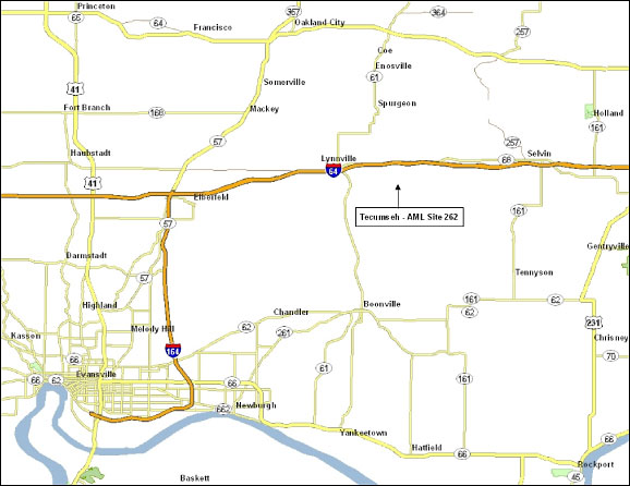
Figure 1-1. Location of the Tecumseh AML Site 262. Created with ArcGIS Desktop Version 9.3.1.
Coal mining operations at this surface mine site were conducted from 1940 through the mid 1950s and recovered the Springfield Coal No. 5 seam. Following completion of mining, problem areas within the site consisted of gob, slurry, spoil, acid impoundments, structures, and trash for a total reclamation site of 270 acres.
2. Remedial Action and Technologies
This very complex project included reclamation of extensive areas of toxic
coal mine refuse, a large impoundment of extremely acidic water, and a continuous
discharge of acid mine drainage (AMD) consisting of highly concentrated sulfuric
acid from the large area of coal refuse. This drainage discharged directly
into Barren Fork Creek resulting in fish kills for miles downstream for many
years.
Multiple reclamation technologies were used at this site, including the following:
- Anoxic limestone drain (ALD)—A large ALD was constructed at the base of the coal slurry dam to treat drainage emanating from the slurry impoundment prior to entering a passive treatment wetland.
- Capping/covers/grading—All barren and exposed coal refuse was graded, covered, and revegetated.
- Constructed treatment wetlands—A 40-acre passive treatment wetland was constructed to treat a series of perpetual acid mine seeps emanating from a 58-acre coal slurry impoundment.
The following is taken or paraphrased from Smith et al. (2001):
Prior to reclamation, the site was marked by a broad, gently contoured mound of spoil and gob and low-lying tailings situated just to the east of a series of flooded mine pits. A perennial stream known as Barren Fork had been diverted by the presence of the main refuse mound. To the west of the pond were acid seeps originating in the abandoned tailing ponds, some smaller spoil ridges, and perhaps subsurface flow from the nearby flooded pits.
The Indiana Department of Natural Resources (DNR) constructed an AMD treatment wetland in the broad floodplain below the Tecumseh spoil hill. The former bed of Barren Fork was incorporated into the largest wetland cell, and a dike was built to divert the stream around the periphery of the wetland. Fresh water is introduced from the northwest along the western edge of the gob pile and directed to flow laterally along the toe of the hill to collect AMD from the seeps. Anoxic limestone drains were installed within the main hill to intercept the seeps and these drains discharge at several points along the first wetland. The combined flow follows a serpentine path around a sequence of baffles directing it back and forth across wetland cells. The base of the treatment cells consists of a bottom layer of sand covered with a 1-foot layer of turkey manure compost, over which the water flows. Agricultural lime was applied as well at a concentration of 200 tons per acre. The effluent at the end of the wetland cells remains somewhat acidic.
3. Performance
According to the DNR, the water control techniques used at this site eliminated
the massive acidic discharges into Barren Fork Creek. Native warm-season
grasses were planted to provide better habitat on reclaimed refuse areas
(Figure 3-1). The site is also part of a wildlife sanctuary, and the selection
of plant species and protection provided by island settings has induced
migratory birds to use the area. This site has much higher potential for
outdoor recreation use now that the environmental concerns have been removed
(Indiana Department of Natural Resources. n.d).
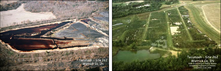
Figure 3-1. Before and after photos of Site 262.
The remedy has been in place for over 12 years. The DNR reports that the cover and wetlands portions of the remedy were successful in returning the site to a productive ecosystem with substantial post-reclamation increases in biodiversity and fish populations (Figure 3-2).
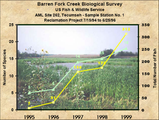
Figure 3-2. Barren Creek biological survey at Site 262.
The ALD portion of the remedy reportedly failed after about one year of operation. In 1998, the crushed limestone inside the failed ALD was removed for examination, and it was discovered that the material was bound into a solid mass consisting primarily of gypsum (Smith et al. 2001).
In 2001, the Indiana Geological Survey issued an open file report (Smith et al. 2001) that presented the results of studies of four AMD treatment wetlands in Indiana, including the Tecumseh AML Site 262. The data generated in this study support the following general statements regarding the effectiveness of AMD treatment wetlands:
- Wetlands are effective at removing and storing toxic metals.
- Dilution is a significant contributor to water quality in these wetlands.
- The wetlands effluents generally meet water quality standards for toxic metals in winter as well as summer.
- The wetlands studied are not very effective at removing sulfate. Establishing alkalinity is essential for the successful removal of sulfate from AMD.
- The estimated iron removal rates suggest that the sizing criteria in general use are accurate and that the wetlands have been sized adequately for iron removal.
- Large wetland cells can be as effective for metals removal as a larger number of smaller cells as long as there are adequate mixing and little channelization and the water level is kept shallow enough to encourage the growth of typha.
- The wetlands that are most successful at metals removal and sequestration are those which incorporate manure-based organic substrates.
- The percentage of metals that are bioavailable in the sediments varies widely from element to element. The distribution of metals between available and residual forms depends on the type of precipitates present and the influence of biological processes, especially sulfate reduction, which are enhanced by the presence of organic substrates. Over time, wetlands should transfer metals from available forms to more stable residual forms, provided that anaerobic conditions persist.
- The rapid precipitation of iron in the initial treatment cells does not simultaneously remove most of the trace metals from the AMD. Significant amounts of these metals pass through to the final treatment cells.
- Potentially toxic metals may accumulate in sediments near the outlets of wetlands. The integrity of the cells should be maintained to prevent the sediments from being flushed from the sites. Metals sequestered in anoxic sediments will become increasingly stabilized over time.
In 2001, three Indiana wetlands, including the Tecumseh AML Site 262, were studied to determine their treatment efficiencies for sulfate removal. Sulfate reduction by microorganisms in constructed wetlands can remove sulfate and dissolved metals and can generate alkalinity. Approximately 100 water samples and 50 soil samples were taken during the winter and summer seasons at the three wetlands and analyzed for sulfate/sulfide concentrations, sulfur isotope values, pH, Eh, and conductivity. Resulting data indicate that the Tecumseh wetland shows little change in influent/effluent sulfate and sulfide values, suggesting that treatment of the influent wastewater by sulfate reduction was inactive for both winter and summer sampling seasons (Fledge and Maynard 2001).
4. Costs
The original feasibility study was completed by McGuire & Shook Corporation
on 6/27/85 at a total cost of $195,190. The engineering plans and specifications
were completed by ATC and Associates, Inc. on 10/22/92 at a total cost
of $215,120. The main construction project was completed by Rust Construction
Company on 6/25/96 at a total cost of $4,518,325. Since then, several maintenance
projects have been completed at a total cost of $39,342.
5. Regulatory Challenges
The main regulatory challenge at this site was meeting the National Pollutant
Discharge Elimination System (NPDES) requirements for the discharge of
the 40-acre acid impoundment. To comply with NPDES, the entire 40 acres
of acid water (75,000,000 gals with a pH as low as 1.8) had to be treated
to standards prior to release into the receiving stream. This necessitated
the construction and operation of a temporary water treatment plant adjacent
to the impoundment. The first phase of this three-phase treatment system
consisted of the blending of 1500 dry tons of hydrated lime (sodium hydroxide
was unavailable in the required amounts at this time) for the lime slurry
reagent. The second phase was the extraction of acid water from the impoundment,
mixing of the lime slurry through the venturi jet pump and static mixer,
and introduction into the treatment cell for a 24-hour retention period.
The final phase was the discharge of treated water into the receiving stream
and pumping of the precipitate sludge into drying cells for later cover
and burial. Total cost for water treatment at this site was $276,000.
6. Stakeholder Challenges
The construction of the 40-acre passive treatment system was probably the
greatest challenge faced at this site. At the time, this was the first
passive treatment system that the Indiana AML program had built and the
largest man-made AMD passive treatment–wetland system in the country. Despite
the unique engineering and construction challenges, the project was successfully
completed and is still fully functional today.
7. Other Challenges and Lessons
Learned
The biggest lesson learned on this project was that of the failed anoxic
limestone drain. The ALD failed because of the high calcium concentrations
in the local environment, which caused the formation of gypsum and plugging
of the system. Since then, we are now able to predict whether or not an ALD
will due to gypsum formation simply by testing the local environment to determine
calcium concentrations.
8. References
Flege, A. E., and J. B. Maynard. 2001. “Sulfate Reduction in Three Indiana
Wetlands Receiving Acid Mine Drainage,” presented at the 35th Annual Meeting,
Geological Society of America, North-Central Section, Normal, Ill., April
23–24. http://gsa.confex.com/gsa/2001NC/finalprogram/abstract_4335.htm.
Indiana Department of Natural Resources. n.d. “Tecumseh Abandoned Mine Land Reclamation Project.” www.in.gov/dnr/reclamation/3507.htm.
Smith, R. T., J. B. Comer, M. V. Ennis, T. D. Branam, S. M. Butler, and P. M. Renton. 2001. Toxic Metals Removal in Acid Mine Drainage Treatment Wetlands. Open File Report 01-03, Geochemistry Section, Indiana Geological Survey.
Stacy, M. 2005. “The Use of Wildlife Enhancement Techniques by the Indiana AML Program,” presented at the 19th Annual Surface Mined Land Reclamation Technology Transfer Seminar, Indiana Society of Mining and Reclamation, December 5–6.