Case Study as part of a Web-based
Technical and Regulatory Guidance
Bark Camp
Clearfield County, Pennsylvania
1. Site Information
1.1 Contacts
Jeff Painter
Pennsylvania Department of Environmental Protection
Telephone: 717-783-9989
E-mail: [email protected]
John Varner
Pennsylvania Department of Environmental Protection
Telephone: 814-472-1900
E-mail: [email protected]
1.2 Name, Location, and Description
The Bark Camp mine complex covers about 1,200 acres in a hilly and
wooded area in the Moshannon State Forest in Clearfield County, just west
of central Pennsylvania (Figure 1-1). It is 3 miles due north of Interstate
80 and 2 miles south of the nearest community, Penfield, in Huston Township.
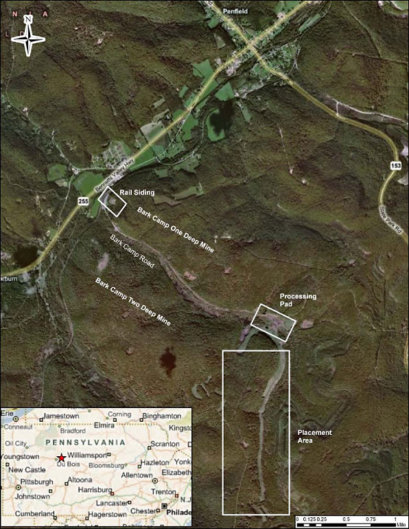
Figure 1-1. Bark Camp Project area map.
Created with ESRI ArcView software using Microsoft Bing maps.
The area’s drainage topography and underlying coal beds tend to dip downward to the north and northwest. The stream at the site, named Bark Camp Run, follows this drainage pattern, running due north from its headwaters for 1.5 miles, turning northwest, and running another 2 miles before emptying into the Susquehanna River. The main feature of interest in this project is the hillside rising about 300 ft above Bark Camp Run on its west that was the dredged material placement area (Figure 1-1). Bark Camp Run is a stream located at latitude 41.1895N and longitude 78.60086W. The entire area contains two layers of coal beds known as the Lower and Middle Kittanning.
The following historical description of the Bark Camp as mine and facility was taken from COAST (2006). The former coal processing facility (which became the dredged material processing facility) was located in the curve of Bark Camp Run, where the coal seams intersect the valley floor, allowing mine shafts to be sunk from ground level along the dip of the seams. In the 1960s deep mining “chased” the upper coal seam (only about 30 inches thick) back into the hillsides on either side of the valley. Tunnels and galleries were dug to follow the dip of the coal bed descending westward towards the direction of the Bennett Branch, and uphill in the opposite direction. Figure 1-1 shows an outline of the abandoned underground mines.
From the 1970s, a surface mining operation attacked the portion of the coal seams outcropping on the face of the hillsides surrounding and sloping down to Bark Camp Run. Because the seams or beds were nearer to the base of the 300-ft-high hill, the overburden was stripped to expose the coal beds only as far back into the hillsides as feasible, dumping the overburden directly into the valley below and creating a bench (and highwall) along the entire 11,000 ft of valley wall surrounding the stream. In part of this area, the upper seam was also stripped, creating a double highwall, with one bench above the other.
When the mine operator constructed the coal preparation plant and loading
facility at the deep mine entrances, a steel culvert was placed in the stream,
and the stream valley was covered with spoil material and coal refuse to
create a 5-acre working area. Coal from the underground mines was processed
at the site and trucked along the downstream portion of Bark Camp Run to
a railroad siding at the mouth of the valley near Penfield.
In 1988, the mine operator declared bankruptcy, and the responsibility for the mine site, along with the cost for its reclamation, devolved to the Commonwealth. The operator abandoned the site, leaving behind the coal preparation plant, mountains of coal silt and refuse, old mining equipment, and rusting vehicles. Figure 1-2 is an aerial view of the processing pad before any reclamation began, looking due south. The double highwall is visible at top, partly covered in trees. It curves around the hill to the left (the demonstration site) and continues for nearly 2 miles. The piles of coal refuse generated acid drainage during rain events, visible in Figure 2-2 as three orange pools.
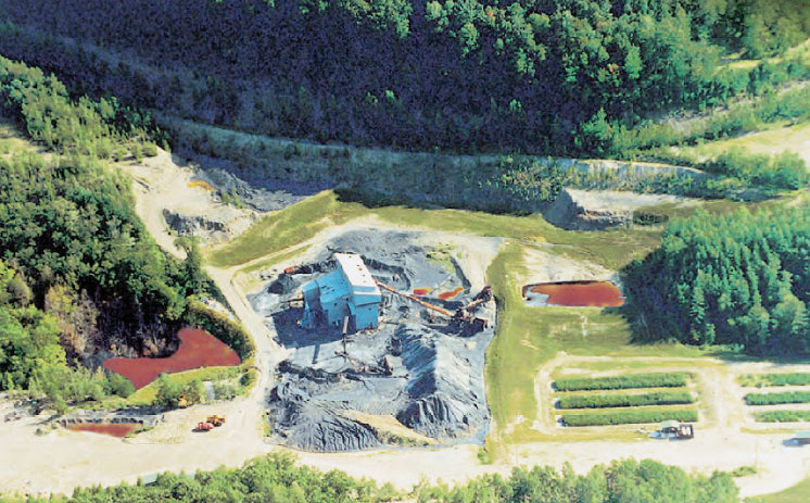
Figure 1-2. Aerial photo looking due south before this project began. A portion of the double highwall is visible at top. The abandoned coal processing facility and piles of coal refuse are at center. Source: COAST 2006.
2. Remedial Action and Technologie
The restoration of the Bark Camp site will
require the remediation of the highwall, encapsulation of the tipple refuse,
injection into the deep mines, reclamation of Bark Camp stream, and the
construction of infiltration barriers for several holding ponds. The highwall
at Bark Camp consists of approximately 11,000 ft of exposure extending
40 ft to a bench and then to an additional 60 ft above this bench of the
hillside (Figure 2-1). Tipple refuse is estimated at approximately 40,000
tons of coal screening originally used to fill in the Bark Camp Creek valley
for construction of the tipple site. The tipple refuse is being added in
lifts to cementitious grouts as the grouts are being places against the
highwall to stabilize and recontour the slope. The refuse is placed so
that it is intimately encapsulated in the grout, thus keeping it in direct
contact with a material with neutralization potential and rejecting water
from contacting the refuse. As the remediation of the highwall is completed,
it is covered with soils and revegetated.
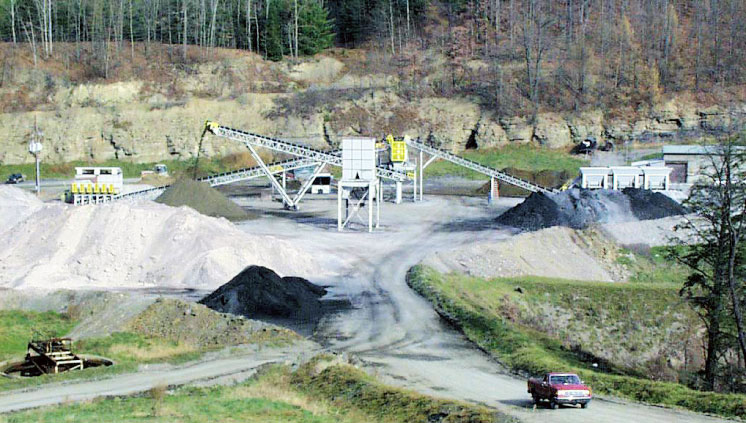
Figure 2-1. Bark Camp processing facilities. Source: COAST 2001.
Finally, the open void space in the deep mines will be closed by pressure-injecting a fly ash–base cementitious grout. The Bark Camp One mine is extensive, stretching for over 6 miles with a wide lateral expanse. In contrast, Bark Camp Two mine is much smaller, extending for nearly 1.5 miles with much less lateral expansion.
The main acid mine drainage (AMD) impacts to the site were discharges from the overflow of the Bark Camp One and Two deep mines as described above. Bark Camp One, to the north of the stream, was overflowing acid drainage at a rate of about 115 gallons per minute, while Bark Camp Two, to the south, had a flow of about 10 gallons per minute. The wetland cells were constructed, and acid drainage from the deep mine discharges were channeled into them. While much was learned about AMD chemistry and passive treatment, this process required constant maintenance to remove precipitated metals. Artificial wetlands, originally constructed to tread AMD, evolved into mine reclamation demonstrations project including the use of fly ash and the creation of artificial topsoil.3. Performance
A dangerous highwall in a state forest, adjacent to state game lands and
a potential source for AMD generation was eliminated. Water is now flowing
overland to the stream rather than back into and along the highwall. Flat
expanses of bare shale and pyritic rock have been restored to a meadow
habitat frequented by bear, deer, elk, bobcat, and turkey. A survey of
Bark Camp Run by the Pennsylvania Fish and Boat Commission in May 2001,
three years after the project began, cited significant water quality improvements
with increasing numbers of macroinvertebrate taxa and some common fishes
at a downstream station in Bark Camp Run, which was formerly sterile due
to the mine drainage impacts left behind by the bankrupt mining operation.
4. Costs
The concept of the demonstration project was to use the economic strength
of port economies to pay for reclamation that would otherwise not be possible.
This site might never have been remediated without this project. However,
given the ongoing need of the Port of NY/NJ, 425,000 cubic yards of
dredged material was transported, processed, and placed at a cost of $19.4
million, or $45 per survey cubic yard, exclusive of dredging. While Bark
Camp was a good location for the purposes of this demonstration, it was
never logistically ideal for such a project, requiring a very long haul
and multiple rehandling of the material.
5. Regulatory Challenges
Application of Clean Water Act (CWA) and Surface Mining Control and Reclamation
Act (SMCRA).
6. Stakeholder Challenges
Three particular issues emerged as the main concerns of the community.
Local residents wanted assurances that the materials brought to the site
would not be hazardous, and particularly, that no unauthorized materials
could be mixed with the dredged material at any place along the transportation
route. Assurances were also sought that steps would be taken to prevent
any “midnight dumping’’ of wastes at the site.
7. Other Challenges and
Lessons Learned
No information available.
8. References
COAST (Clean Ocean and Shore Trust).
2001. “Mine Reclamation Using Dredged Materials and Coal Ash.” Slide presentation.
COAST. 2006. The Bark Camp Demonstration Project.
Colorado State University. 1998. Tailings and Mine Waste ’98: Proceedings, 5th International Conference on Tailings and Mine Waste. January 26–28, Fort Collins, Colo. Rotterdam, Netherlands: Balkema.