Case Study as part of a Web-based
Technical and Regulatory Guidance
McNeely Green Reclamation Tar Creek
Superfund Site
Ottawa County, Oklahoma
1. Site Information
1.1 Contacts
David Cates
Oklahoma Department of Environmental Quality
707 N. Robinson
P.O. Box 1677
Oklahoma City, OK 73101-1677
Telephone: 405-702-5124
E-mail: [email protected]
1.2 Name, Location, and Description
McNeely
Green Reclamation Tar Creek Superfund Site, longitude 36.9833222, latitude
94.7836611
The McNeeley Green site is located in the NW/4 of Section 23-T29N-R23E in Ottawa County, Oklahoma (Figure 1-1) and contains 54 acres of mine waste, locally called “chat,” lying in a flat rural agricultural setting. The site is part of the Tar Creek Superfund Site of northeast Oklahoma, which resulted from wastes associated with abandoned lead and zinc mines of the Tri-State Mining District that operated from the early 1900s through 1970. Mining here consisted of underground room and pillar mines about 200 feet below land surface. Processing of the lead and zinc sulfide ores occurred at mills located about every 40 acres (due to leasing requirements of the Native American–owned lands) and resulted in many large piles of chat covering the approximately 40 square mile superfund site. At the mills, the ore was processed by crushing and simple gravity separation methods initially, and later floatation was employed. The resulting waste rock, chat, is composed of mainly chert with minor amounts of limestone and dolomite with particle sizes ranging from 9.51 mm to less than 0.075 mm, with most of the mass in the coarser sizes. Much of the original chat volume is gone due to its use as aggregate in asphalt and concrete, gravel for roads, rock metal for railroads, and general fill material. About 35 million cubic yards of chat remains to be dealt with at the site. The recent record of decision calls for continued chat sales for aggregate in asphalt as the remedy.
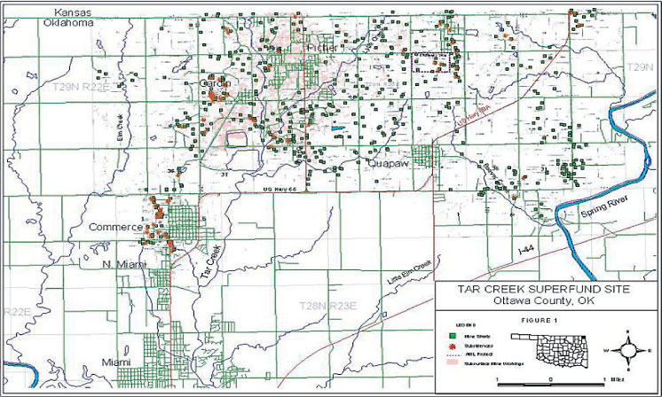
Figure 1-1. Locational map.
2. Remedial Action and Technologies
The McNeely Green pilot project is located several miles east of Picher in
the NW/4 of Section 23-T29N-R23E in Ottawa County, Oklahoma and consisted
of reclamation of approximately 52 acres of land covered with an average
of 1.5 feet of chat, two open mineshafts, and two large subsidence areas.
The work began in August 2003 and consisted of removal of chat pile bases
down to the native soil horizon and translocation of approximately 82,000
cubic yards of this chat material to fill two large subsidences (collapses),
one that contained water. The average levels of lead, zinc, and cadmium in
the chat were 2,353 ppm, 24,875 ppm, and 143 ppm, respectively. Soil below
the chat had average concentrations of lead, zinc, and cadmium of 15.1 ppm,
227.8 ppm, and <1 ppm, respectively. A sample of bluestem grass showed
3.7 mg/kg, 76 mg/kg, and <1.0 mg/kg for lead, zinc, and cadmium concentrations
(OKCC 2003).
The reclamation plan also involved filling and sealing the two open shafts, exploring and resealing seven other shafts, burying on-site rubbish, building three ponds, capping the chat-filled subsidence areas with clay soil, and vegetating 52 acres with fescue/ryegrass/clover. The land was plowed, contoured and amended (with nutrients) prior to establishing a vegetative cover over the reclaimed land.
After reclamation, a monitor well was installed in the chat-filled subsidence by DEQ using the statewide drilling contract. Comparisons of the water quality of surface water and groundwater in the subsidence, mine shaft, and nearby Roubidoux well were made before and after filling the subsidence with chat.
The demonstration project required a landowner agreement with remediation to agricultural standards. The remediation of the Tar Creek Superfund site will be to residential standards, and institutional controls may be required for some areas where mine waste is buried in a landfill or capped in place or areas that pose subsidence potential.3. Performance
The goal of the demonstration project was to restore land to productive
use, i.e., clean up to agricultural standards. It also reduced surface exposures
to lead, zinc, and cadmium. Current remediation goals in soils of 500 mg/kg
for lead, 1,100 mg/kg for zinc, and 10 mg/kg for cadmium have been established
for the Superfund site with MCLs used for groundwater criteria. Comparisons
of the pre- and post-remediation water quality were made to demonstrate the
impacts to groundwater.
4. Costs
- Capital: $6,734/acre or $4.38/cubic yard
- Operation and maintenance: $0.22/cu yd ($13,500 for monitor wells and water analyses, $4,500 for soil analyses)
5. Regulatory Challenges
The demonstration project was conducted by the Oklahoma Conservation Commission
to show that mine waste land could be restored to public use. It led to the
development of the Oklahoma Plan for Tar Creek, a comprehensive and cooperative
remediation plan between the state, the Quapaw Tribe, and the University
of Oklahoma, with appropriations of $45 million in federal funding secured
by Senator James Inhofe, the chairman of the U.S. Senate Committee on Environment
and Public Works.
The demonstration project was designed to show that immediate environmental improvements can be achieved at much reduced costs when work is done cooperatively at the state and local level. No single federal agency involved in remediation has jurisdiction to holistically address all the issues at abandoned mine sites.
6. Stakeholder Challenges
The McNeely Green demonstration project reclaimed land to agricultural standards.
While this made the land usable for farming, the property value remained
impacted since the land is still part of the Superfund site and areas of
potential subsidence still exist, thus limiting the land to nonresidential
use. The application of public funds to remedies that did not address human
health and safety issues was criticized.
7. Other Challenges and Lessons
Learned
Excavation using a scraper (rather than an excavator) provided better and
faster remediation of soils. The excavator may leave furrows of chat from
the teeth on the bucket and requires a separate loading step while the scraper
can excavate, haul, and dump. The costs are lower and the work can be completed
faster than equivalent federal projects due to the elimination of layers
of bureaucracy and fewer contractors using state and local operations.
8.0
References
OKCC (Oklahoma Conservation Commission). 2003. “Tar Creek Progress Report,
2/10/03.”
Summary Report and Water Quality Analyses for the McNeely-Green Monitoring Well, McNeely-Green Demonstration Project, Tar Creek Superfund Site, Ottawa County, Oklahoma. February 2005.