Case Study as part of a Web-based
Technical and Regulatory Guidance
Copper Basin
Polk County, Tennessee
1. Site Information
1.1 Contacts
Carrie L. Stokes, CHMM, PE. (CS #2)
Telephone: 615-252-4343
E-mail: [email protected]
Mark Bowers, CIH (CS #2)
Telephone: 919-552-9675
E-mail: [email protected]
Ben Faulkner (CS #27)
Telephone: 304-487-2886
E-mail: [email protected]
1.2 Name, Location
and Description
Copper Basin Mining Site is in the Lower Potato Creek Watershed near
Ducktown, Polk County, in southeastern Tennessee near the North Carolina
and Georgia borders and comprises an area of approximately 50 square
miles adjacent to lands administered by the Cherokee National Forest
(Figure 1-1). The Copper Basin, north of the Ocoee River, is drained
by North Potato Creek and Davis Mill Creek, which empty into the Ocoee
River. The basin has been host to 150 years of copper mining, beneficiation
and mineral processing, sulfuric acid, and other chemical production
that have left a legacy of environmental degradation. Deep mining was
the primary method, with a few surface-mining operations. In addition
to mining and related operations, associated support infrastructure (railroads,
equipment storage, and other waste processing facilities) can be found
throughout the basin. Remnants of these mining practices remain scattered
throughout portions of both North Potato Creek and Davis Mill Creek watersheds.
The affected media are soil, sediment, surface stream water, surface
pool water, and groundwater.
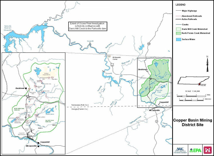
Figure 1-1. Copper Basin Mining District.
The Copper Basin Mining Site (Site) is located in southeastern
Tennessee, near the North Carolina and Georgia borders and comprises an area
of approximately 50 square miles adjacent to lands administered by the Cherokee
National Forest. The Copper Basin, north of the Ocoee River, is drained by
North Potato Creek and Davis Mill Creek, which empty into the Ocoee River.
The Basin has been host to 150 years of copper mining, beneficiation and
mineral processing, sulfuric acid and other chemical production that have
left a legacy of environmental degradation. Deep mining was the primary method
with a few surface mining operations. In addition to mining and related operations
associated support infrastructure (railroads, equipment storage, and other
waste processing facilities) can be found throughout the Basin. Remnants
of these mining practices remain scattered throughout portions of both North
Potato Creek and Davis Mill Creek watersheds. The affected media are soil,
sediment, surface stream water, surface pool water and groundwater.
2. Remedial Action and Technologies
The site comprises 50 square miles with acidic waters, providing aluminum,
copper, iron, manganese and zinc as the primary contaminant. Secondary
contaminants include arsenic, cadmium, cobalt, copper, lead, mercury, selenium,
and sulfate. Remedial actions at these sites are overseen and must comply
with the Clean Water Act, CERCLA, and the Tennessee Voluntary Cleanup program.
The site cleanup goal is mitigation of human health risk and ecological
risk in the stream environment and is evaluated using the contaminant concentrations
in water.
This large site has used multiple technologies:
- Backfilling and subaqueous disposal. A hydraulically
isolated mine collapse is used for disposal of materials with high acid-generating
potential. Supernatant is pumped for classic precipitation treatment. This
type treatment has operated for four years and is anticipated as a permanent
solution.
- Bioreactor. Anoxic trenches were installed between mine
waste pile and creek at MCP restored stream segment.
- Capping, covers, and grading. Impermeable caps (PVC
liner over excavated tailings at the London Mill) and geosynthetic clay
liner (GCL, used over waste material at the London Mill Plant site) have
been used where residual materials may still continue to be a significant
potential source of acid and/or metals. Covering and grading have been
used extensively along with lime stabilization for low acid rock drainage–potential
areas. This type of treatment has operated for 10+ years and is a considered
to be a long-term solution with possibility of becoming a permanent solution.
- Chemical PPT. Conventional lime treatment is conducted
in a traditional water treatment plant as well as in a system using a
20-acre former open-pit mine as the settling basin. This type of treatment
has operated for 10+ years. The operating life of this treatment was
undetermined at the time the case study information was reported. Because
of the unique drainage at the site (a diversion dam once conveyed the
entire 10,000-acre watershed through a tunnel to another watershed),
storm-water flows are attenuated by the dam. There is also a 20-acre
pit situated in the general vicinity of the of the unique drainage system.
This pit is situated in stream and serves as the clarifier. The layout
of the treatment plant is efficient. The treatment plant mixes the relatively
mild acid drainage in the creek with the mine drainage from the bottom
of the pit to produce high-density sludge in the rapid mix tank. This
arrangement required intense modeling and design and constant monitoring
with automation and process control.
- Chemical stabilization. Lime treatment and revegetation
of mine waste.
- In situ treatment. In situ treatment has been restricted to lime neutralization of materials in place prior to grading and covering. This type of treatment has operated for 10+ years and is a long-term solution and may become a permanent solution.
Secondary treatment technologies include the following:
- Anoxic limestone drain (ALD). A single standard ALD was installed for one low-flow source. This type of treatment has been operated for 10+ years (limited effectiveness). The longevity of this treatment is undetermined.
- Constructed treatment wetlands
- Bench- and pilot-scale pilot anaerobic wetland (SRB-mediated) treatment testing has been used to show the capabilities of the technology. This treatment has operated for 10+ years and is a permanent treatment. A GCL liner was used to bottom line the anaerobic wetland which was placed over waste material.
- 1-acre aerobic wetland with 0.25-acre manganese biofilter.
3. Performance
Human health criteria are based on 10E-5 cancer risk, noncancer hazard index <1,
and blood lead concentrations below protective levels based on IEUBK and/or
ALM modeling for future land uses. The ecological criterion is biological
integrity in site streams as represented by the benthic macroinvertebrate
community. Specific quantitative objectives were established based on bioregion
reference streams. Water quality criteria and benchmarks are used to gauge
progress and to monitor specific treatment system performance.
4. Costs
Cost of activities:
- Capital: Variable
- Operation and maintenance: Variable
5. Regulatory Challenges
No significant regulatory barriers have been encountered with technologies
applied to date. The Copper Basin project benefits from a strong industry/agency/public
stakeholder organization that has helped facilitate the expedited implementation
of remedial solutions. Use of biological integrity rather than numerical
water quality criteria was a major advance in the application of water
quality regulations. It acknowledges the fact that fauna in the Basin may
be uniquely adapted to establish health communities even if concentration-based
criteria are not met in all cases.
Land use controls will be required upon completion of remedial/restoration activities. This need is primarily associated with waste materials that will remain in place although physical hazards will also affect how the property will ultimately be used.
6. Stakeholder Challenges
The public has participated in the process and has been pleased with progress.
Glenn Springs Holdings has worked closely with the public to improve the quality
of life, health and human safety, recreational and educational offerings,
and property value protection in the historic and unique Copper Basin.
7. Other Challenges and Lessons
Learned
An effective industry/regulatory working group has been the key to success.
Regular meetings and intervening conference calls and general correspondence
built a remarkable amount of credibility and trust between the parties. As
a consequence, there has been a willingness on the part of all parties to
carefully consider remedial technology proposals, render constructive (rather
than antagonistic) feedback, reach decisions quickly and work together to
optimize design/implementation strategies which has allowed the project to
proceed at a fast pace.
Deed restrictions will limit development in lined and sensitive areas. Five miles of specially constructed fence limits access to mine subsidence areas.
The success of the Copper Basin project is a long and complicated story. It began with industry, academia, and agencies working together to restore vegetation to a uniquely scarred area. Glenn Springs has focused on land restoration and water quality enhancement by employing adaptive management in an iterative approach. Working closely with Tennessee Department of Environment and Conservation and USEPA, Glenn Springs has used the following general approach: Characterize the drainage and environmental influences, divert unaffected drainage, capture and treat affected drainage, sequester acid-producing materials, mitigate remaining problems with passive systems, and evaluate with biologic indicators.
8. References
U.S. Environmental Protection Agency. n.d. “Copper Basin Mining District.” https://www.epa.gov/region4/superfund/sites/npl/tennessee/copbastn.html.