Case Study as part of a Web-based
Technical and Regulatory Guidance
Ore Hill Mine
Grafton County, New Hampshire
1. Site Information
1.1
Contacts
USDA Forest Service
Contact: Tim Buxton
Telephone: 603-466-2713
E-mail: [email protected]
1.2 Name,
Location, and Description
Within
the Baker River watershed near the town of Warren is the former Ore Hill
Mine site. It is located approximately 3 miles northwest of downtown Warren
(Lat. 43°56'12.79"N, long. 71°56'53.52"W), Pemigewasset
Ranger District, in Grafton County, western New Hampshire (see Figure 1-1).
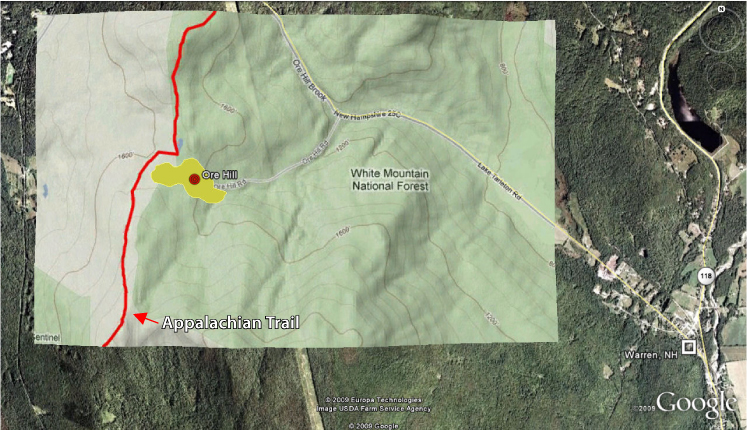 Figure
1-1. Location of Ore Hill Mine site in the town of Warren.
Figure
1-1. Location of Ore Hill Mine site in the town of Warren.Source: Relief map superimposed on a satellite image from GoogleEarth (2009).
The historic Ore Hill mine site discharged acidic water with high metal content, severely impacting about a mile of Ore Hill Brook. The site is also close to the Appalachian National Scenic Trail (see Figure 1-2).
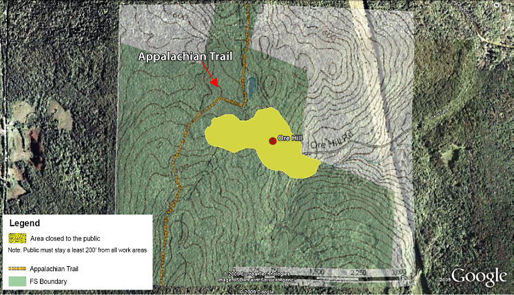
Figure 1-2. Historic Ore Hill Mine site.
Source: USFS (2006) map superimposed on October 2006 satellite image from GoogleEarth (2009).
The site had 48-foot-wide vein which contained an ore deposit of several sulfide minerals including pyrite (iron), galena (lead), and sphalerite (zinc) in an area of 10 acres. The ore deposit was intermittently mined for silver, lead, copper, and zinc from 1834 to 1915. It was estimated (Secord 1984) that the mine production between 50,000 and 100,000 tons. Over the years, the mine tunnel used to extract that material extended more than 650 feet in depth. The site is the only known source of acid mine water impacting water quality in the Baker River watershed.
After many stages of failed mining operations and metallurgical processes since its discovery in 1834, the mine was abandoned in 1915. Several piles of tailings and a pile of waste rock were left on site. A small drainage with poor water quality ran through the site and impacted flora, water quality, and aquatic species downstream in Ore Hill Brook.
In 1937, the U.S. Government acquired approximately half of the mine site
to be part of the White Mountain National Forest. In 1979 the National Park
Service acquired the rest of the site. At around this same time, the Appalachian
Trail, which had traversed the unsightly mine property, was rerouted several
hundred feet to the west of the mine site (see Figure 1-2). The Forest Service
is currently addressing the site under its Comprehensive Environmental Response,
Compensation, and Liability Act (CERCLA) authority (USFS 2009a).
2. Remedial Action and Technologies
In 1984, the Forest Service, in coordination with the National Park Service,
recontoured the tailings piles, capped the area with a thin layer of limestone
and several inches of topsoil, and seeded the area (USFS 2009a). Downstream
surface water quality improved following this effort, but water quality problems
remained. In 1988, additional work was completed, including diverting some
on-site surface water flow and lining channels with limestone (BRWA 2005).
These actions improved the visual quality of the area, and downstream water
quality reportedly improved.
By 2000, when the Forest Service conducted a CERCLA Preliminary Assessment, several acidic seeps had appeared on site, the grassed soil cap on the tailings area was failing, and surface water at and below the site exceeded background and state water quality criteria for several dissolved metals by as much as two to three orders of magnitude (USFS 2009a).
Up to six seeps still discharge acidic water (pH 3.3) with high metals content from the waste rock pile and the tailings area. Ore Hill Brook, which is located 1 mile downstream from the site, is essentially devoid of aquatic species due to aluminum precipitate in the streambed and to low pH stream water with levels of dissolved zinc, copper, and cadmium that are toxic to aquatic organisms. Water quality impacts are diluted further downstream, and impacts to the Baker River (4 miles from the Ore Hill site) are unknown but are not believed to be significant (BRWA 2005).
In 2006, a removal action construction was completed to mitigate the environmental impacts. In coordination with the New Hampshire Department of Environmental Services, Forest Service remedial work at the mine site in 2006 increased the pH to approximately neutral and decreased hazardous metals by 80%, although several metals downstream of the site remain well above state water quality criteria.
The remedial work included excavating approximately 36,000 cubic yards of tailings and waste rock, treatment with solid EnviroblendTM mix, and then hauling the material in unlined and soil-capped on-site repository area. Enviroblend is a phosphate-based treatment used to reduce the availability of metals.
The target parameters to be monitored at the site are, as primary contaminants, acidity, copper, lead, zinc, and as secondary contaminants, aluminum and cadmium. Monitoring will continue at the site for at least the next several years.3. Performance
Prior to the major Removal Action in 2006, acidic seeps at the mine had
very low pH levels and concentrations of several metals of aluminum, cadmium,
copper, lead, and zinc that far exceeded New Hampshire surface water quality
criteria In addition, downstream waters were toxic to aquatic life for at
least a mile. (USFS 2009b, see also http://www.fs.usda.gov/detail/whitemountain/landmanagement/projects/?cid=stelprdb5209644).
Post-work data show significant improvements in surface water leaving the mine site compared to pre-work data (Figure 3-1). pH has generally increased to near the background level, and dissolved metals have decreased significantly. Zinc, lead, and copper are the metals of greatest concern in surface water, and while this project is seeing approximately 80% reductions compared to prework levels, the final goal is 95% or more reduction in these metals from the site. If 95% metal reductions at the mine site can be achieved, water quality further downstream could meet water quality standards.
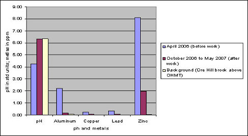
Figure 3-1. Ore Hill Mine Site Tributary (OHMT) data point (just downstream of the tailings excavation area) concentrations of pH, aluminum, copper, lead and zinc before and after remedial works in the site.
Note: pH is in standard units, and metals data are in parts per million, equivalent to milligrams/liter.
Source: USFS 2009b.
From Figure 3-1, the following can be noted:
- pH has increased from 4.2 (blue bar) to near 6.2 (red bar), which satisfies the background pH (yellow bar) in the surface water.
- Aluminum decreased from 2.21 ppm to 0.16 ppm since the end of October 2006, while the background concentration is 0.07 ppm.
- Copper also decreased from 0.23 ppm to 0.06 ppm (background copper in below the scale 0.00 ppm).
- Lead show a decrease from 0.35 ppm to 0.08 ppm (as with copper, lead background level is below the scale).
- Zinc decreased from 8.11 ppm to 1.98 ppm with a background concentration of 0.03 ppm.
Surface water and groundwater data from the area around the repository are insufficient to draw any firm conclusions at this time but tentatively do not appear to indicate degradation due the placement of the treated tailings and waste rock in the repository.
4. Costs
- Capital: $3,200,000
- Operations and maintenance: $10,000 per year and indefinitely
- Monitoring: $30,000 per year and indefinitely
5. Regulatory Challenges
The Forest Service has CERCLA authority and is lead agency for the site,
working with state on mutual goals. It is anticipated that the land will
be marked for permanent government retention and limited, if any, future
development in the area.
6. Stakeholder Challenges
The public is pleased that Forest Service took action to remediate the contamination
generated from the historic Ore Hill site.
7. Other Challenges
and Lessons Learned
As mine wastes are Bevill-exempt under RCRA, the phosphate treatment approach
to stabilize metals was uncommon, so relatively little directly analogous
sites and information could be found.
The treatment approach was either the use of portland cement or phosphate stabilization. The logic of the decision to treat with phosphate included a perceived "longer" long-term effectiveness in New England climate.
8. References
BRWA (Baker River Watershed Association).
2005. “Ore Hill Mine Information.” http://www.bakerriverwatershed.org/watershed_info/oreHill.html.
Secord, T. 1984. The Geology and Geochemistry of the Ore Hill Zinc-Lead-Copper Deposit, Warren, New Hampshire. M.S. thesis, University of Wisconsin–Madison.
USFS (U.S. Forest Service). 2006. “Order 06-01: Map of Area closed by order of the White Mountain National Forest Supervisor.”
USFS. 2009a. “Ore Hill History.” http://www.fs.usda.gov/detail/whitemountain/landmanagement/projects/?cid=stelprdb5209640.
USFS. 2009b. “Ore Hill Site Work Under CERCLA, Including CERCLA Removal Action.” http://www.fs.usda.gov/detail/whitemountain/landmanagement/projects/?cid=stelprdb5209647.